
Reading the Land
How Ecoregion's Hold the Keys to Understanding Your Local Ecosystems

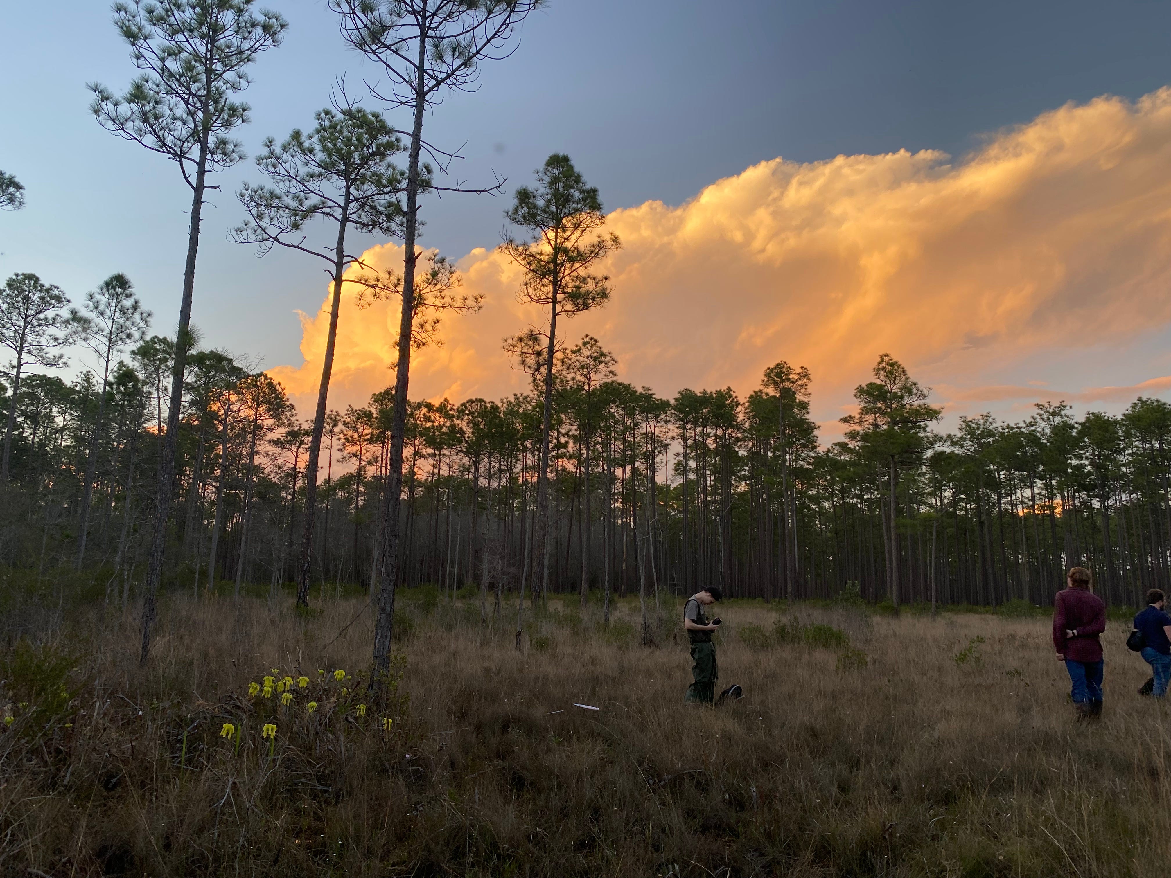
On your last adventure, did you ever notice or wonder why the landscape changed so suddenly? Perhaps the grassland you found yourself walking in suddenly turned into a woodland or forest. Or maybe you went on a road trip and watched as the land grew flat, mountainous, or swampy. You may have asked why we get those types of plants or ecosystems here, or why you find a certain plant or animal in one spot but not another.
While there are many valid answers to these questions, such as evolution, climate, temperature, rainfall, altitude, disturbance, and so on. One of the first places to start when trying to understand the landscape and ecosystems around us is through ecoregions.
It probably comes as no surprise that the very landscape you stand on was formed by millions of years of geologic processes. I won’t pretend to be a geologist, but I know enough to be dangerous. Geology is a fundamental piece of the ecological puzzle. It influences the structure of the land, the chemistry of soils, the flow of water, minerals, and nutrients. Geologic features affect everything from microclimates to resource availability for plants and animals. Geology, along with climate, interacts over time, shaping one another. Tectonic plates shift, creating mountain ranges that then shift weather patterns. Things like erosion from glaciers, freezing and thawing, rainfall, rivers, and oceans continuously reshape the surface of the Earth. Together, geology and climate set the conditions that form ecosystems and influence the evolution of the life forms that inhabit and thrive in them.
As you can see, this becomes endlessly complex and for the same reason endlessly fascinating!
How, then, do we begin to grasp these interactions?
Ecoregions!
Ecoregions are a way of grouping and delineating land based on shared geology, climate, vegetation, wildlife, hydrology, land formation, soils, and ecological processes. They provide a framework for understanding why certain ecosystems exist in specific locations and, in turn, why particular plants and animals are found there. Ecoregions also reveal how these systems respond to both natural forces and human influence over time.
So let’s dive in!
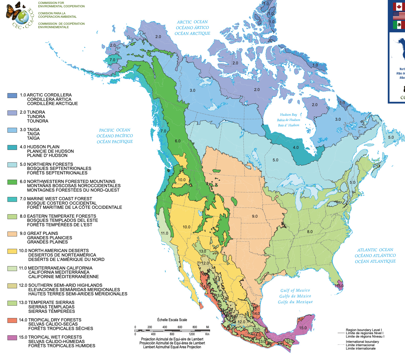
Per the EPA’s classification of North American ecoregions, there are 4 levels of classification, with each one gaining in specificity.
Level one delineates 12 ecoregions, most of which probably will sound familiar from grade school, like the Great Plains, Arctic, Tundra, Deserts, Temperate Forests, etc. These represent broad-scale regions across North America.
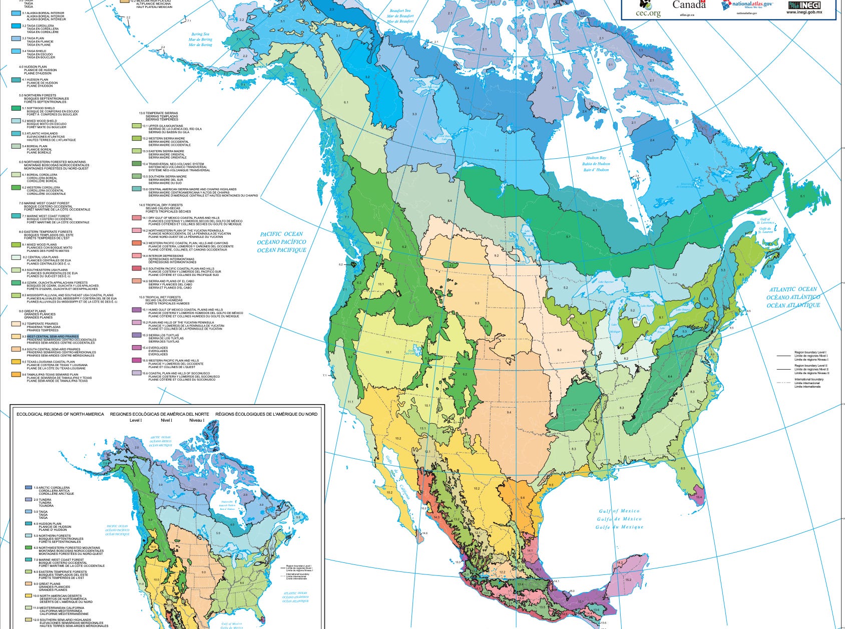
As we reach level 2, we begin to see these regions split up. For my midwestern friends, we begin to see the Great Plains now separated into Temperate Prairies, West Central Semi-Arid Prairies, and so on. For my southern friends, we see the Eastern Temperate Forest split into the Southeastern Plains, the Mississippi Alluvial Plain, the Coastal Plain, and the Ozark-Ouachita Appalachian Forest.
If that sounds confusing at first… well, it is…sort of.
How can a mountain range in Arkansas be part of the same ecoregion as the Appalachian Mountains? Great question, I’m glad you asked! Both the Ouachita Mountains and the Appalachians formed roughly 280 million years ago. Though they were shaped by different orogenies (mountain-building events), the Appalachians, being in their third major uplift at the time, were connected during the collisions that formed the supercontinent Pangaea.
When Pangaea began to break apart around 220 million years ago, the connected mountain ranges began to erode and drift into the positions we see today. Because of this shared geological history, what is now split geographically into two regions is still linked ecologically. Hence, the split in ecoregion. Evidence of this connection can still be seen in their similar rock formations, ecosystems, and closely related plant and animal species, many of which are found nowhere in the vast expanse between them.
This is one example of this complex process, so keep this in mind as we move forward.
Let’s take a look at levels 3 & 4 now.
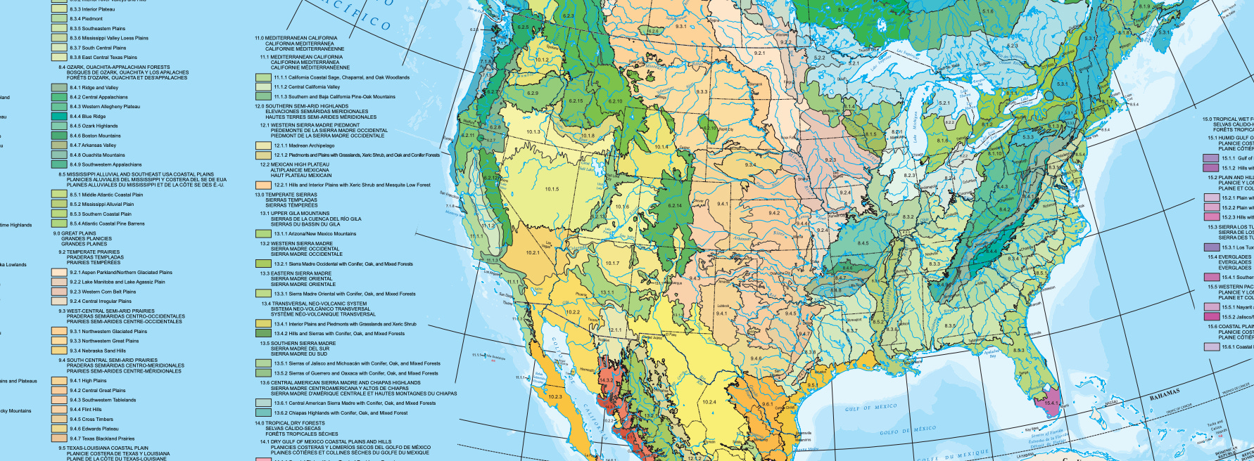
I know it looks a bit intimidating, but what if I were to throw out some regions like the Blue Ridge, Nebraska Sand Hills, Flint Hills, Cross Timbers, Coastal Plain, Ridge & Valley?
If you want to geek out, level 4 delves even further. At level 4, differences that make one ridge, valley, or watershed ecologically distinct from another might only be a few miles apart. These differences reflect the subtle shifts in soils, elevation, and species communities. Level 4 can be found along with the others on the EPA's Ecoregion Website.
As we enter the realm of level 4, ecosystems begin to emerge, and this is where websites like NatureServe Explorer and your new tools for ecoregion identification come in handy. Tools such as these help scientists, ecosystem managers, and enthusiastic nature lovers like us identify and map specific ecosystems like Limestone Glades, Longleaf pine savannas, Floodplain forests, Pennyroyal Prairie, and Seepage bogs, to name a few.


Unfortunately, many of these systems have been dramatically altered or destroyed. Picture taking a giant eraser and destroying large portions of the maps I just showed you. Across North America, all of these ecosystems, like Tallgrass Prairie, Longleaf Pine Savanna, Limestone Glades, Hardwood Forests, Woodlands, Flatwoods, Bogs, Barrens, and many others, have been reduced to a fraction of their former range. Invasive species, habitat fragmentation, pollution, and in some cases, fire suppression have pushed many native species to the brink. And now, as legislative protections like the Endangered Species Act face political threats, the urgency to protect and restore these places has never been greater.
With all that being said, here’s the hopeful part: awareness is powerful. When we understand what makes a place ecologically unique, we gain the power to protect it. When our ignorance of the natural world falls away, and we realize that we are not separate from nature, but a part of it, we begin to see our role in these living systems more clearly.
And here’s the best part! You don’t need to be a scientist to make a difference. The most meaningful first step is simply to get outside.
So go!
Look up your local ecoregions. Learn their names. Explore them. Walk them. Sit with them. Get to know their rhythms, their species, their textures, sounds, and smells.
You’ll start to notice patterns and feel like you’re seeing your surroundings for the first time.
When you begin to learn how to read the land, you start to care for it, and that’s where the real change begins.
If you have one, leave a comment about your favorite ecoregion below!
If you enjoy reading nature Substacks, I encourage you to check out Dr. Bob Leonard at Cedar Creek Nature Notes, Dian Porter at My Gaia, Larry Stone at Listening to the Land, Al Batt at Naturally Al Batt, and Dr. Estes at GALAS: Natural History of a Southern Conservationist
You won’t be disappointed!
“Love of nature is the spring from which stewardship flows. In contrast, disconnection from nature leads to apathy in the face of all environmental problems. A useful way to define love is sustained, compassionate attention. Paying sincere attention to, and developing a rich curiosity about others helps us to be kind. This attention takes work and improves with practice.” - John Muir Laws